VR simulation of reclaimed mining landscape.

From Pit to Paradise: How VR Could Reimagine Mining Reclamation

"Explore the use of virtual reality in transforming post-mining landscapes into sustainable environments and assess the transformative potential of VR in ecological restoration."


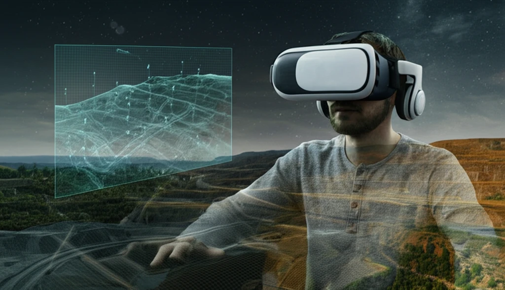
For years, mining operations have left indelible scars on the earth, often resulting in environmental degradation and disruption of local ecosystems. As society becomes more aware of these environmental impacts, innovative solutions are needed to reclaim and restore these damaged landscapes. Enter Virtual Reality Geographic Information Systems (VRGIS), a cutting-edge technology that combines virtual reality with geographic information systems to simulate, visualize, and plan ecological restoration projects.

VRGIS isn't just about pretty visuals; it's a powerful tool that allows stakeholders to virtually explore and interact with proposed reclamation plans. This technology helps visualize landscapes in both real and imaginary environments, incorporating animation and audio to provide a comprehensive understanding of the project's potential impact. The ability to acquire, display, and process 3D data makes VRGIS invaluable for addressing environmental challenges in a visually engaging and technically sound manner.

The integration of VRGIS in mining reclamation addresses numerous challenges, including integrating diverse temporal and spatial resolutions and accurately modeling complex digital landscapes. It allows for the simulation of landscape dynamics and human perception, which is vital for effective reclamation planning. By adopting VRGIS, environmental managers can develop strategies that not only restore ecological balance but also consider the aesthetic and functional integration of reclaimed areas into the surrounding environment.

VRGIS: A Systemic Approach to Reclamation

VR simulation of reclaimed mining landscape.

The development of a VRGIS for opencast mine reclamation is a complex, systemic project involving multiple stages, from data collection to model design and implementation. The initial phase focuses on gathering data from various sources, including field surveys, maps, and remote sensing images. This data is then used to construct a comprehensive GIS geodatabase, which serves as the foundation for creating detailed virtual models of the mining environment.

A critical aspect of VRGIS is the ability to model various environmental elements, such as dumps, pits, industrial sites, and vegetation. These models are constructed using a combination of GIS data, 3D modeling software like 3DMAX, and specialized vegetation modeling tools. The integration of these models within platforms like ArcGlobe allows for the efficient display and query of raster and GIS data, enhancing the analytical capabilities of the system. This integration is crucial for providing a holistic view of the reclamation site and supporting informed decision-making.

VRGIS offers a suite of features that significantly enhance the planning and execution of reclamation projects:
  • Spatial Analysis: Tools for analyzing spatial data to understand environmental impacts.
  • 3D Visualization: Creating realistic and interactive 3D models of landscapes.
  • Data Integration: Combining data from various sources into a unified system.
  • Simulation Capabilities: Simulating the effects of different reclamation strategies.
VRGIS technology is not only valuable for visualization but also for its analytical capabilities in the geoprocessing environment. By using remote sensing for land cover analysis and extracting data from high-resolution images like those from QUICKBIRD, VRGIS can accurately map and monitor reclaimed vegetation. This detailed analysis supports the long-term management and sustainability of reclaimed landscapes, ensuring that restoration efforts align with ecological goals.

Looking Ahead: The Future of Mining Reclamation

VRGIS represents a significant advancement in the field of mining reclamation, offering unprecedented capabilities for planning, visualizing, and implementing restoration projects. As technology continues to evolve, VRGIS will likely become an indispensable tool for environmental managers seeking to transform degraded landscapes into thriving ecosystems. By embracing VRGIS, the mining industry can move towards a more sustainable and environmentally responsible future, ensuring that post-mining environments are not only restored but also contribute positively to ecological diversity and community well-being.

About this Article -

This article was crafted using a human-AI hybrid and collaborative approach. AI assisted our team with initial drafting, research insights, identifying key questions, and image generation. Our human editors guided topic selection, defined the angle, structured the content, ensured factual accuracy and relevance, refined the tone, and conducted thorough editing to deliver helpful, high-quality information.See our About page for more information.

Everything You Need To Know

1

What exactly is Virtual Reality Geographic Information Systems (VRGIS) and how does it aid in ecological restoration projects for post-mining landscapes?

Virtual Reality Geographic Information Systems (VRGIS) is a cutting-edge technology that merges virtual reality with geographic information systems. It allows stakeholders to virtually explore and interact with proposed reclamation plans by visualizing landscapes in both real and imaginary environments. Through animation and audio, VRGIS provides a comprehensive understanding of a project's potential impact, utilizing the acquisition, display, and processing of 3D data.

2

How does VRGIS integrate and model environmental data during the opencast mine reclamation process, and what specific tools and platforms are utilized?

VRGIS integrates data from various sources such as field surveys, maps, and remote sensing images to construct a comprehensive GIS geodatabase. This geodatabase is then used to create detailed virtual models of the mining environment, including elements like dumps, pits, industrial sites, and vegetation. These models are constructed using GIS data, 3D modeling software like 3DMAX, and specialized vegetation modeling tools. Integration within platforms like ArcGlobe allows for efficient display and query of raster and GIS data.

3

What are the core features of VRGIS, and how do these capabilities improve the planning and execution of mining reclamation projects?

VRGIS offers several key features: spatial analysis tools to understand environmental impacts, the creation of realistic and interactive 3D models of landscapes, data integration from various sources into a unified system, and simulation capabilities to assess the effects of different reclamation strategies. It enhances planning and execution of reclamation projects by offering analytical capabilities in a geoprocessing environment and using remote sensing for land cover analysis, including data from high-resolution images like those from QUICKBIRD to accurately map and monitor reclaimed vegetation.

4

In what ways does VRGIS assist environmental managers in creating effective reclamation strategies that consider both ecological balance and the aesthetic integration of reclaimed areas?

By adopting VRGIS, environmental managers can develop reclamation strategies that not only restore ecological balance but also consider the aesthetic and functional integration of reclaimed areas into the surrounding environment. The detailed analysis that VRGIS facilitates supports the long-term management and sustainability of reclaimed landscapes, ensuring that restoration efforts align with ecological goals. Its visualization and analytical capabilities facilitate well-informed decision-making, addressing the challenges of integrating diverse temporal and spatial resolutions and accurately modeling complex digital landscapes.

5

Looking forward, how is VRGIS expected to evolve and further contribute to the future of mining reclamation and environmental conservation efforts?

VRGIS is positioned to become an indispensable tool for environmental managers seeking to transform degraded landscapes into thriving ecosystems. Continued technological advancements will enhance VRGIS's capabilities, facilitating more sustainable and environmentally responsible mining practices. This includes not only restoring post-mining environments but also contributing positively to ecological diversity and community well-being. The analytical and simulation capabilities of VRGIS will likely drive innovation in ecological restoration techniques and landscape management strategies.

Newsletter Subscribe

Subscribe to get the latest articles and insights directly in your inbox.