Illustration of the Sul-Riograndense Shield's cross-section, highlighting geological features and data visualization.

Unveiling Earth's Secrets: How Scientists Decoded the Ancient History of Southern Brazil

"New research decodes the complex geological history of Southern Brazil's Sul-Riograndense Shield, revealing insights into the formation of continents and the potential for undiscovered resources."


Imagine a vast, ancient landscape, sculpted over billions of years, holding within it the secrets of our planet's formation. This is the Sul-Riograndense Shield, a geological marvel in Southern Brazil, and the focus of a remarkable scientific endeavor. Recent research has unlocked a wealth of information about this region, offering unprecedented insights into the Earth's history and the potential for future discoveries.

The Sul-Riograndense Shield isn't just any geological formation; it's a window into the past, revealing the story of how continents were formed, how they collided, and how they eventually separated. The shield's complex structure, shaped by tectonic forces over eons, provides invaluable clues about the Earth's evolution. By studying its rocks and structures, scientists are piecing together a puzzle that spans billions of years.

This article will explore the innovative methods scientists are using to decode the shield's secrets, from advanced geophysical surveys to detailed geological analysis. We'll also delve into the significance of these findings, highlighting how they are reshaping our understanding of the Earth's history and opening up new avenues for resource exploration.

Decoding the Shield: The Tools of the Trade

Illustration of the Sul-Riograndense Shield's cross-section, highlighting geological features and data visualization.

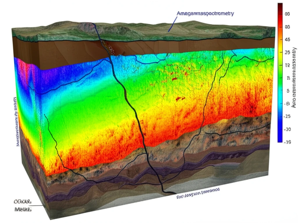
The study of the Sul-Riograndense Shield is a multidisciplinary undertaking, blending cutting-edge technology with traditional geological techniques. Scientists employ a variety of tools to unravel the shield's complex history, each providing a unique perspective on its structure and composition.

One of the primary tools used is aerogammaspectrometry, which measures the natural radioactivity of rocks near the surface. This technique helps scientists map the distribution of different rock types, revealing the shield's major geological units. Complementing this is aeromagnetometry, which measures the Earth's magnetic field variations, providing insights into the composition and structure of the crust below the surface.

  • Aerogammaspectrometry: Measures natural radioactivity to map rock types.
  • Aeromagnetometry: Analyzes magnetic field variations for insights into crustal structure.
  • Geological Mapping: Traditional field work to understand rock formations and structures.
  • Geochronology: Dating rocks using radioactive elements to determine their age.
By combining these methods, researchers create a comprehensive picture of the shield's geology, revealing hidden structures, identifying potential resource deposits, and gaining a deeper understanding of the Earth's dynamic processes. The integration of these different techniques is what makes this research so significant.

A New Chapter in Earth's Story

The research on the Sul-Riograndense Shield represents a significant step forward in our understanding of Earth's history. By combining advanced technologies with traditional geological methods, scientists are not only deciphering the shield's past but also paving the way for future discoveries. This research underscores the importance of continued exploration and the potential for uncovering valuable resources, while also reminding us of the dynamic and ever-evolving nature of our planet.

About this Article -

This article was crafted using a human-AI hybrid and collaborative approach. AI assisted our team with initial drafting, research insights, identifying key questions, and image generation. Our human editors guided topic selection, defined the angle, structured the content, ensured factual accuracy and relevance, refined the tone, and conducted thorough editing to deliver helpful, high-quality information.See our About page for more information.

This article is based on research published under:

DOI-LINK: 10.1590/0001-3765201520140495, Alternate LINK

Title: Integrated Evaluation Of The Geology, Aerogammaspectrometry And Aeromagnetometry Of The Sul-Riograndense Shield, Southernmost Brazil

Subject: Multidisciplinary

Journal: Anais da Academia Brasileira de Ciências

Publisher: FapUNIFESP (SciELO)

Authors: Léo A. Hartmann, William R. Lopes, Jairo F. Savian

Published: 2016-02-02

Everything You Need To Know

1

What is the significance of the Sul-Riograndense Shield in Southern Brazil?

The Sul-Riograndense Shield is a geologically significant formation in Southern Brazil that offers a window into the Earth's ancient history. Its complex structure, shaped by tectonic forces over billions of years, provides invaluable clues about how continents were formed, collided, and separated. Studying the rocks and structures of the Shield helps scientists piece together a puzzle that spans billions of years, revealing insights into the Earth's evolution.

2

What are some of the cutting-edge techniques being used to study the Sul-Riograndense Shield?

Scientists are employing a combination of advanced technologies and traditional geological methods to study the Sul-Riograndense Shield. These techniques include aerogammaspectrometry, which measures the natural radioactivity of rocks to map different rock types, and aeromagnetometry, which analyzes magnetic field variations to provide insights into the crustal structure below the surface. Additionally, traditional geological mapping and geochronology, which involves dating rocks using radioactive elements, are crucial components of the research.

3

How does aerogammaspectrometry contribute to understanding the geology of the Sul-Riograndense Shield?

Aerogammaspectrometry measures the natural radioactivity of rocks near the surface of the Sul-Riograndense Shield. By mapping the distribution of different rock types based on their radioactivity, scientists can identify the shield's major geological units. This technique helps in understanding the overall composition and structure of the region, revealing hidden geological features and potential areas of interest for further exploration. Without aerogammaspectrometry, identifying and mapping these rock types across large areas of the Sul-Riograndense Shield would be much more difficult and time-consuming.

4

Beyond understanding Earth's history, what other potential benefits could arise from studying the Sul-Riograndense Shield?

Studying the Sul-Riograndense Shield not only deepens our understanding of Earth's history but also opens up new avenues for resource exploration. By identifying hidden structures and geological units, scientists can pinpoint potential deposits of valuable resources within the shield. The research underscores the importance of continued exploration and highlights the potential for uncovering these resources, which could have significant economic and societal implications.

5

How does the research on the Sul-Riograndense Shield reshape our understanding of continent formation?

The research conducted on the Sul-Riograndense Shield provides a detailed look into the processes involved in the formation, collision, and separation of continents. By analyzing the shield's complex structure and the age of its rocks, scientists gain valuable insights into the tectonic forces that have shaped our planet over billions of years. This understanding helps refine existing models of continental drift and plate tectonics, offering a more complete and accurate picture of Earth's dynamic history. The Sul-Riograndense Shield serves as a real-world example that informs and validates theoretical models of continental evolution.

Newsletter Subscribe

Subscribe to get the latest articles and insights directly in your inbox.