A person uses augmented reality to explore an urban environment.

Unlock Your City: How Augmented Reality is Revolutionizing Urban Exploration

"Discover the groundbreaking research that reveals how interaction strategies in augmented reality can transform spatial cognition and navigation in urban environments."


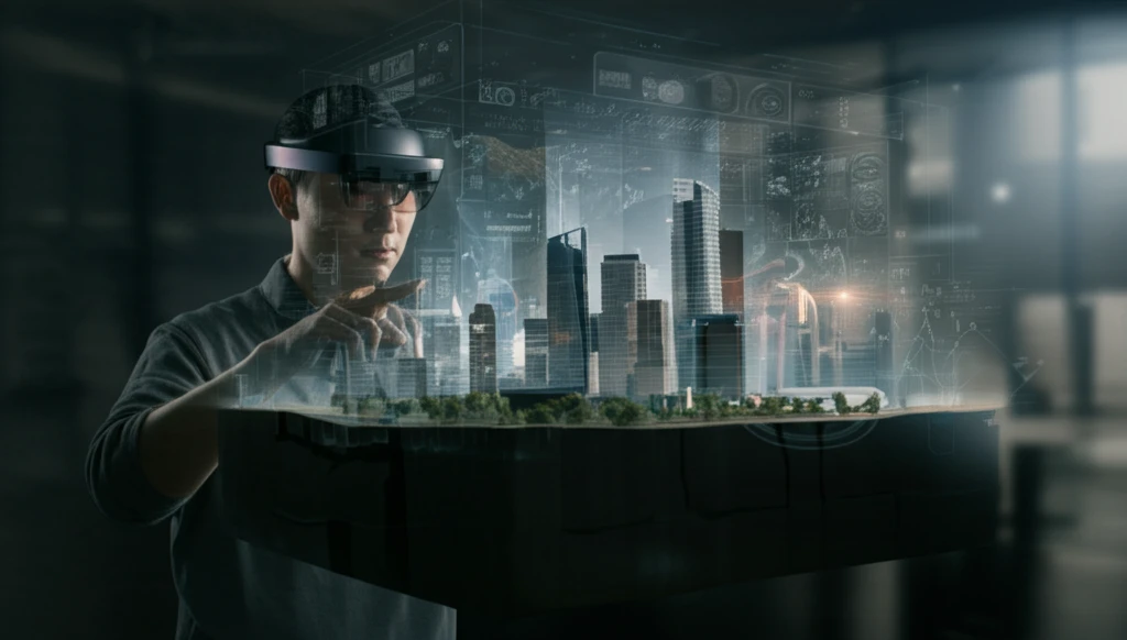
Imagine navigating a bustling city with a digital map overlaid onto your view, guiding you effortlessly through the streets. This is the promise of augmented reality (AR) geo-visualization, a technology poised to revolutionize how we interact with urban environments. Recent advancements in AR technology, particularly with head-worn devices like the Microsoft HoloLens, have made it possible to superimpose rich, interactive 3D models onto the real world, offering intuitive navigation through gestures and voice commands.

However, the effectiveness of AR geo-visualization depends on how users interact with these interfaces. Do certain interaction strategies lead to better spatial memory and navigation performance? A groundbreaking study published in Human-Computer Interaction sought to answer this question by examining user interactions within a 3D urban environment displayed through the Microsoft HoloLens. The research provides valuable insights into how we can design AR applications to enhance spatial cognition and improve navigation in complex urban spaces.

This article delves into the key findings of this research, exploring the specific interaction strategies that predict successful navigation outcomes. We'll uncover how manipulating the 3D city model, switching perspectives, and even individual spatial abilities play a crucial role in leveraging AR for effective urban exploration. Get ready to discover how AR is transforming the way we see and navigate our cities.

The Power of Perspective: How Interaction Strategies Shape Spatial Cognition

A person uses augmented reality to explore an urban environment.

The study focused on how users interacted with a 3D model of an urban environment using the Microsoft HoloLens. Participants were tasked with memorizing a route between two locations, and their interactions with the model were meticulously logged, including their position, orientation, scale, and viewing angle. This data was then correlated with their performance on two subsequent virtual navigation tasks: following the learned route and navigating back to the origin from memory.

The results revealed distinct interaction patterns and their impact on navigation. Notably, participants who initially pitched the 3D model upward to gain an overhead, map-like view demonstrated superior performance in following the learned route. This suggests that adopting a survey perspective early on enhances the encoding of spatial information, making it easier to recall and follow the route.

  • Overhead View: Participants who started by pitching the model upward performed better on route following.
  • Perspective Switching: Frequent switching between interactions correlated with better path efficiency in returning to the origin.
  • Individual Differences: Spatial ability and experience (e.g., military training) influenced interaction strategies and navigation performance.
Conversely, those who frequently switched between different interactions, such as zooming, panning, and rotating the model, exhibited greater efficiency in navigating back to the route's origin. This indicates that active perspective transformation during the learning phase fosters a more flexible mental map, enabling users to adapt and navigate effectively even when faced with unexpected detours or changes in direction. Moreover, the study highlighted the role of individual differences in spatial abilities, with participants possessing higher spatial skills demonstrating more adaptable interaction strategies.

Designing Intuitive AR Experiences for Urban Exploration

These findings have significant implications for the design of AR geo-visualization applications. By understanding how different interaction strategies affect spatial cognition and navigation, designers can create more intuitive and effective AR experiences. For instance, applications could initially present an overhead view of the environment to facilitate route learning, while also encouraging users to actively switch between perspectives to develop a more comprehensive understanding of the urban landscape. Ultimately, the goal is to leverage the power of AR to transform the way we experience and navigate our cities, making urban exploration more accessible, efficient, and enjoyable for everyone.

About this Article -

This article was crafted using a human-AI hybrid and collaborative approach. AI assisted our team with initial drafting, research insights, identifying key questions, and image generation. Our human editors guided topic selection, defined the angle, structured the content, ensured factual accuracy and relevance, refined the tone, and conducted thorough editing to deliver helpful, high-quality information.See our About page for more information.

This article is based on research published under:

DOI-LINK: 10.1080/07370024.2018.1531001, Alternate LINK

Title: Interaction Strategies For Effective Augmented Reality Geo-Visualization: Insights From Spatial Cognition

Subject: Human-Computer Interaction

Journal: Human–Computer Interaction

Publisher: Informa UK Limited

Authors: Aaron L. Gardony, Shaina B. Martis, Holly A. Taylor, Tad T. Brunyé

Published: 2018-10-30

Everything You Need To Know

1

What is AR geo-visualization and how is it changing how we interact with cities?

AR geo-visualization uses Augmented Reality (AR) to overlay digital information, like maps and 3D models, onto the real world. This is transforming urban exploration by providing intuitive navigation through the use of head-worn devices such as the Microsoft HoloLens. Instead of relying solely on traditional maps or signs, users can interact with a digital representation of the city that adapts to their view, making navigation easier and more efficient. This technology promises a more immersive and user-friendly way to experience urban environments.

2

How did the study on the Microsoft HoloLens investigate interaction strategies for urban navigation?

The study observed users interacting with a 3D model of an urban environment displayed through the Microsoft HoloLens. Participants were given tasks such as memorizing routes and then navigating them. Researchers meticulously logged the users' interactions with the model, including their position, orientation, scale, and viewing angle. They correlated these interaction patterns with the users' navigation performance on tasks like route following and returning to the origin, revealing how specific interaction strategies influenced their spatial cognition and navigation abilities.

3

What are the key interaction strategies that led to better navigation outcomes in the study?

The research highlighted a few key interaction strategies. Participants who initially pitched the 3D model upward to gain an overhead, map-like 'Overhead View' showed better performance in following the learned route. 'Perspective Switching', or frequently changing views, correlated with more efficient navigation back to the starting point. Also, the study found that individual differences in spatial abilities, such as experience and training, influenced how users interacted with the model and their overall navigation outcomes.

4

Why is the 'Overhead View' important for learning routes, and what are the implications for AR application design?

Adopting an 'Overhead View' early on, like a map, enhances the encoding of spatial information. It helps users build a better understanding of the route's layout and relationships between different locations. For AR application design, this suggests that applications should initially present users with an overhead view to aid route learning. This is especially helpful for new users to understand a new urban environment. The goal is to create AR experiences that leverage these findings to transform the way we experience and navigate cities.

5

Beyond interaction strategies, what other factors played a role in navigation performance using AR, and how can this inform the design of future AR experiences?

Beyond interaction strategies, individual spatial abilities and 'Perspective Switching' significantly influenced navigation performance. Participants with higher spatial skills demonstrated more adaptable interaction strategies, leading to better navigation outcomes. Frequent 'Perspective Switching' fostered a more flexible mental map, enabling users to navigate effectively even when faced with unexpected detours. For future AR experiences, designers should consider incorporating features that encourage perspective changes to promote a more comprehensive understanding of the environment. Recognizing individual differences in spatial abilities, applications can provide personalized guidance or training to enhance navigation skills, making urban exploration more intuitive and enjoyable for everyone.

Newsletter Subscribe

Subscribe to get the latest articles and insights directly in your inbox.